Lumispot Offers top-notch quality assurance and after-sales service, certified by national, industry-specific, FDA, and CE quality systems. Swift customer response and proactive after-sales support.
Subscribe to Our Social Media For Prompt Post
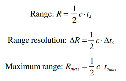
Airborne LiDAR sensors can either capture specific points from a laser pulse, known as discrete return measurements, or record the complete signal as it returns, called full-waveform, at fixed intervals like 1 ns (which covers about 15 cm). Full-waveform LiDAR is mostly used in forestry, while discrete return LiDAR has broader applications across various fields. This article primarily discusses discrete return LiDAR and its uses. In this chapter, we'll cover several key topics about LiDAR, including its basic components, how it works, its accuracy, systems, and available resources.
Basic Components of LiDAR
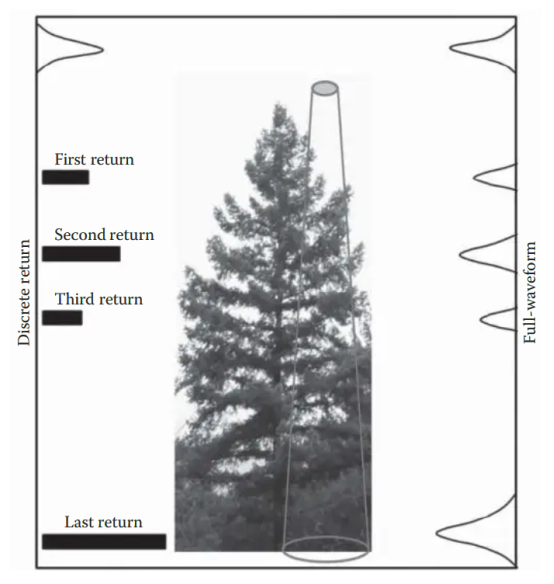
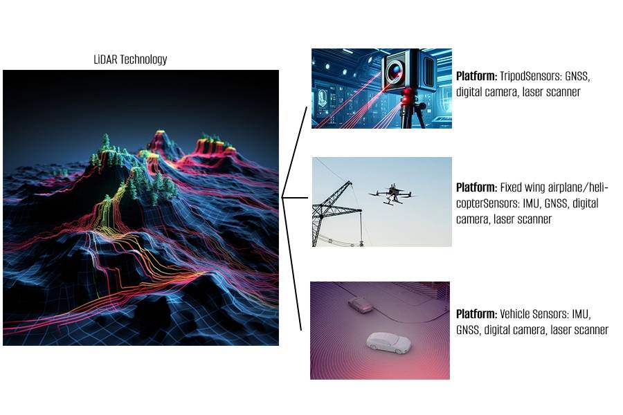
Ground-based LiDAR systems typically use lasers with wavelengths between 500–600 nm, while airborne LiDAR systems use lasers with longer wavelengths, ranging from 1000–1600 nm. A standard airborne LiDAR setup includes a laser scanner, a unit for measuring distance (ranging unit), and systems for control, monitoring, and recording. It also includes a Differential Global Positioning System (DGPS) and an Inertial Measurement Unit (IMU), often integrated into a single system known as a position and orientation system. This system provides precise location (longitude, latitude, and altitude) and orientation (roll, pitch, and heading) data.
The patterns in which the laser scans the area can vary, including zigzag, parallel, or elliptical paths. The combination of DGPS and IMU data, along with calibration data and mounting parameters, allows the system to accurately process the collected laser points. These points are then assigned coordinates (x, y, z) in a geographic coordinate system using the World Geodetic System of 1984 (WGS84) datum.
How LiDAR Remote Sensing Works? Explain in a Simple Way
A LiDAR system emits rapid laser pulses towards a target object or surface.
The laser pulses reflect off the target and return to the LiDAR sensor.
The sensor precisely measures the time it takes for each pulse to travel to the target and back.
Using the speed of light and the travel time, the distance to the target is calculated.
Combined with the position and orientation data from GPS and IMU sensors, the precise 3D coordinates of the laser reflections are determined.
This results in a dense 3D point cloud representing the scanned surface or object.
Physical Principle of LiDAR
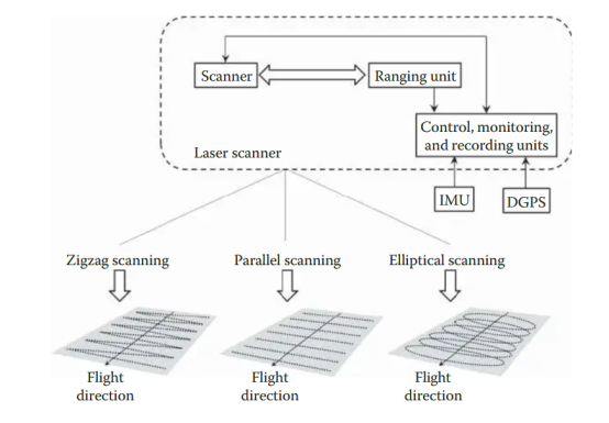
LiDAR systems use two types of lasers: pulsed and continuous wave. Pulsed LiDAR systems work by sending out a short light pulse and then measuring the time it takes for this pulse to travel to the target and back to the receiver. This measurement of round-trip time helps determine the distance to the target. An example is shown in a diagram where the amplitudes of both the transmitted light signal (AT) and the received light signal (AR) are displayed. The basic equation used in this system involves the speed of light (c) and the distance to the target (R), allowing the system to calculate the distance based on how long it takes for the light to return.
Discrete return and full-waveform measurement using airborne LiDAR.
A typical airborne LiDAR system.
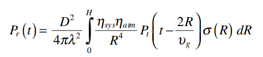
The measurement process in LiDAR, which considers both the detector and the characteristics of the target, is summarized by the standard LiDAR equation. This equation is adapted from the radar equation and is fundamental in understanding how LiDAR systems calculate distances. It describes the relationship between the power of the transmitted signal (Pt) and the power of the received signal (Pr). Essentially, the equation helps to quantify how much of the transmitted light is returned to the receiver after reflecting off the target, which is crucial for determining distances and creating accurate maps. This relationship takes into account factors like signal attenuation due to distance and interactions with the target surface.
Applications of LiDAR Remote Sensing
LiDAR remote sensing has numerous applications across various fields:
Terrain and topographic mapping for creating high-resolution digital elevation models (DEMs).
Forestry and vegetation mapping to study tree canopy structure and biomass.
Coastal and shoreline mapping for monitoring erosion and sea-level changes.
Urban planning and infrastructure modeling, including buildings and transportation networks.
Archaeology and cultural heritage documentation of historical sites and artifacts.
Geological and mining surveys for mapping surface features and monitoring operations.
Autonomous vehicle navigation and obstacle detection.
Planetary exploration, such as mapping the surface of Mars.
Need a Free Consulation?
LiDAR Resources:
An incomplete list of LiDAR data sources and free software is provided below.LiDAR data sources:
1.Open Topography http://www.opentopography.org
2.USGS Earth Explorer http://earthexplorer.usgs.gov
3.United States Interagency Elevation Inventory https://coast.noaa.gov/ inventory/
4.National Oceanic and Atmospheric Administration (NOAA) Digital Coasthttps://www.coast.noaa.gov/dataviewer/#
5.Wikipedia LiDAR https://en.wikipedia.org/wiki/National_Lidar_Dataset_(United_States)
6.LiDAR Online http://www.lidar-online.com
7.National Ecological Observatory Network—NEON http://www.neonscience.org/data-resources/get-data/airborne-data
8.LiDAR Data for Northern Spain http://b5m.gipuzkoa.net/url5000/en/G_22485/PUBLI&consulta=HAZLIDAR
9.LiDAR Data for the United Kingdom http://catalogue.ceda.ac.uk/ list/?return_obj=ob&id=8049, 8042, 8051, 8053
Free LiDAR Software:
1.Requires ENVI. http://bcal.geology.isu.edu/ Envitools.shtml
2.FugroViewer (for LiDAR and other raster/vector data) http://www.fugroviewer.com/
3.FUSION/LDV (LiDAR data visualization, conversion, and analysis) http:// forsys.cfr.washington.edu/fusion/fusionlatest.html
4.LAS Tools (Code and software for reading and writing LAS files) http:// www.cs.unc.edu/~isenburg/lastools/
5.LASUtility (A set of GUI utilities for visualization and conversion of LASfiles) http://home.iitk.ac.in/~blohani/LASUtility/LASUtility.html
6.LibLAS (C/C++ library for reading/writing LAS format) http://www.liblas.org/
7. MCC-LiDAR (Multi-scale curvature classification for LiDAR) http:// sourceforge.net/projects/mcclidar/
8.MARS FreeView (3D visualization of LiDAR data) http://www.merrick.com/Geospatial/Software-Products/MARS-Software
9.Full Analyze (Open source software for processing and visualizing LiDARpoint clouds and waveforms) http://fullanalyze.sourceforge.net/
10.Point Cloud Magic (A set of software tools for LiDAR point cloud visualiza-tion, editing, filtering, 3D building modeling, and statistical analysis in forestry/ vegetation applications. Contact Dr. Cheng Wang at wangcheng@radi.ac.cn)
11.Quick Terrain Reader (Visualization of LiDAR point clouds) http://appliedimagery.com/download/ Additional LiDAR software tools can be found from the Open Topography ToolRegistry webpage at http://opentopo.sdsc.edu/tools/listTools.
Acknowledgments
- This article incorporates research from "LiDAR Remote Sensing and Applications" by Vinícius Guimarães, 2020. The full article is available here.
- This comprehensive list and detailed description of LiDAR data sources and free software provides an essential toolkit for professionals and researchers in the field of remote sensing and geographical analysis.
Disclaimer:
- We hereby declare that some images displayed on our website have been collected from the internet for the purpose of promoting education and information sharing. We respect the intellectual property rights of all original creators. The use of these images is not intended for commercial gain.
- If you believe that any of the content used infringes upon your copyright, please contact us. We are more than willing to take appropriate measures, including removing images or providing proper attribution, to ensure compliance with intellectual property laws and regulations. Our goal is to maintain a platform that is rich in content, fair, and respectful of others' intellectual property rights.
- Please contact us through the following contact information, email: sales@lumispot.cn. We promise to take immediate action upon receipt of any notice and guarantee 100% cooperation to resolve any such issues.
>> Related Content
Post time: Apr-16-2024


